
How to Export and Clean Horizontal Alignments in Civil 3D
Learn standard procedures for extracting Civil 3D alignment exports, validating vertical curve K-values, calculating superelevation runoff transitions, and processing DTM survey datasets.
ℹ️ Instructional Notice:
All station chainages and coordinate references demonstrated in these workflows use synthetic example data created solely for technical instruction and software verification.
Tutorial Courses (4)
How to Export and Clean Horizontal Alignments in Civil 3D
Learn standard professional workflows for exporting horizontal curves from Autodesk Civil 3D, stripping duplicate tangent coordinates, validating radii against AASHTO/ERA design speeds, and formatting administrative submittal tables.
Step 1: Locate and Inspect Alignment in Civil 3D Toolspace
Open your road design project drawing (.dwg) in Autodesk Civil 3D. In the Toolspace window, ensure the Prospector tab is active. Expand the Alignments tree, followed by Centerline Alignments.
Workspace screenshot pending source and publication clearance.
Select your active roadway alignment (e.g., Mainline_CL). Right-click and choose Edit Alignment Geometry... to open the Alignment Layout Tools toolbar. Inspect the Alignment Grid View to ensure all curve entities—tangents, circular arcs, and transition spirals—are fully tangential with no geometric kinks or broken linkages.
└── [Prospector]
└── Alignments
└── Centerline Alignments
└── Mainline_CL (Right-click > Properties / Edit Geometry)
Step 2: Generate the Alignment Curve Report
Navigate to the Toolspace > Toolbox tab. Expand the Reports Manager folder and select the Alignment subcategory. You have two primary export options:
- Incremental Stationing Report: Outputs coordinates at regular station intervals (e.g., 20m or 25m). While useful for staking, this report floods outputs with thousands of redundant tangent points.
- Curve Report / Alignment Curve Relation Report: Directly isolates curve parameters including Point of Curvature (PC), Point of Intersection (PI), Point of Tangency (PT), Radius (R), Delta Angle, Tangent Length (T), and Arc Length (L).
Double-click Alignment Curve Relation Report. In the dialog box, select only the active centerline alignment, uncheck unused entities, and choose CSV or HTML as the export target.
Step 3: Strip Duplicate Tangent Lines & Parse Geometry
Raw alignment exports frequently contain hundreds of redundant intermediate tangent coordinates that clutter client submittal tables. For a synthetic example, use the horizontal alignment CSV on the Templates page. Open the CSV or upload it to Infradigital CAD's Horizontal Alignment Formatter.
The client-side parsing engine executes a geometry filter that:
- Identifies contiguous linear segments and eliminates intermediate 20m interval points between control vertices.
- Calculates the true intersection point (PI) coordinates from backward and forward tangent bearings:X_PI = [ (Y2 - Y1) - X2*tan(B2) + X1*tan(B1) ] / [ tan(B1) - tan(B2) ]
- Formats station chainages into standardized notation (e.g.,
14+350.00).
Step 4: Validate Minimum Curve Radii Against Design Standards
Every horizontal circular curve must comply with the minimum radius threshold R_min for the assigned corridor design speed (V) and maximum superelevation (e_max):
Compare your extracted radii against AASHTO 2018 and ERA 2013 Table 8-1 minimum thresholds:
| Design Speed (km/h) | Max Superelevation (e_max) | Max Side Friction (f_max) | Minimum Radius (R_min) |
|---|---|---|---|
| 50 km/h | 8.0% (0.08) | 0.16 | 85 m |
| 80 km/h | 8.0% (0.08) | 0.14 | 230 m |
| 100 km/h | 8.0% (0.08) | 0.12 | 395 m |
Any curve whose radius falls below R_min will trigger an instant non-compliance warning in the formatter.
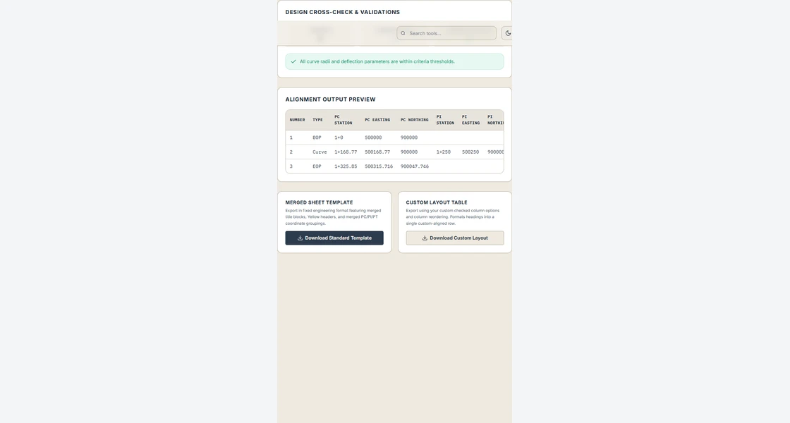
Step 5: Export Clean PC-PI-PT Tables & Compile Submittal
Once validated, click Export Clean Submittal Table. The tool outputs a standardized Microsoft Excel workbook formatted with standard corporate headers, Times New Roman typography, and proper column widths:
Curve No | Control Point | Station   | Easting (X)  | Northing (Y)  | Radius (m) | Delta (deg) | Tangent (m) | Length (m)
C-01     | PC            | 0+120.50  | 489201.35    | 1002381.20    | 450.00     | 24° 15' 30" | 96.72       | 190.53
C-01     | PI            | 0+217.22  | 489295.40    | 1002403.50    | -          | -           | -           | -
C-01     | PT            | 0+311.03  | 489382.11    | 1002446.80    | -          | -           | -           | -
This formatted table is ready for insertion into drawing title sheets, design calculation briefs, and contractor stakeout packages.